Skip to a section:
• Map of the Route • In Flight and on the Ground • The Fliers and Explorers Globe
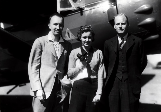
Mary Meader's adventures began on September 16, 1937. Taking off from her home airport in Kalamazoo, Michigan, she and her first husband, Robert U. Light, embarked on a long journey that they hoped would create one of the first aerial photographic records of western South America and East Africa. Aerial photography was still a young field, having emerged only a few decades earlier as an essential tool for military intelligence during World War I. Mary and Richard's intentions were, however, different. They wanted to record land forms, farms, ports, and industrial facilities that portrayed human activity on a grand scale. By the end of their 18-month odyssey, they had covered over 35,000 miles and Mary had taken over 2,000 photos. Some of those spectacular images are landmarks in the photography of these continents, capturing features never before seen from the air, such as Peru's Nazca lines and Uganda's Ruwenzori Mountains.
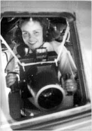
The journey was arduous, the weather capricious, and the photography demanded skill and daring. Weighing only 95 pounds, Mary braced herself and her 20-pound camera on the window frame, securing it with clothesline and leaning out of the window. She used a Fairchild F-8 aerial camera and a 35 mm Leica.
Unlike military photographers, Mary often had only one chance to get a good shot. On a typical day, the Lights would arise at 4:00 a.m. and fly until 11:00 a.m. After lunch they would visit the farms, mines, and settlements they planned to photograph the next day.
The results of their trip are now well known among aviators. The historic significance of the flight has been recognized by the National Air and Space Museum of the Smithsonian Institution, whose staff has dedicated a corner of the Museum to the Lights' unprecedented fly-over of Africa.
Follow the Meaders' route: click the magnify icon ( ) in the lower right to zoom in. As you move your mouse, the map will pan. Click again to zoom out.
Legend is at upper right.
Click on the map to zoom out.
Click here to download a large, printable version of the map.
The Lights' route took them from Cape Town through the varied landscapes of sub-Saharan Africa all the way north to the Mediterranean. From Cairo, they flew west to Tunisia, and finally north again to Corsica.
The map above, like Mary Meaders aerial photographs, reflects an earlier 20th-century reality that has altered considerably. Published in Richard U. Lights book, Focus on Africa, it depicts the political borders of Africa as he perceived them at the time of the trip.
Most of the photographs on display here relate to northeast Africa. These images include views of Sudanese and Egyptian Nile Valley landscapes and monuments now irrevocably transformed by both natural and human processes in the 71 years that have passed since the Lights expedition.
One enduring area of interest in Kelsey Museum research is the Egyptian Nile Valley. Mary Meaders photographs predate by decades the construction of the High Dam at Aswan and the concomitant move of many Nubian monuments such as the Temple of Ramesses II at Abu Simbel. In the cases of the pyramids at Saqqara and Giza, the wider spatial and architectural contexts of these mortuary complexes were still largely unknown in 1938. The photographs also capture a moment of discovery significantly predating the major excavation campaigns of the later 20th century.
In preparation for her epic journey in 1937-38, Mary Meader took flying lessons and learned Morse code so that she could serve as co-pilot, navigator, and radio operator. She also practiced using an aerial camera on flights all over Michigan. Although the Lights Bellanca CH-400 Skyrocket monoplane was one of the most up-to-date planes of the 1930s, it was not pressurized, insulated, or heated. At higher altitudes Mary wore a fur coat and boots, breathed oxygen through a wooden mouthpiece, and communicated with the pilot by intercom. Her stunning aerial views were shot with a Fairchild F-8 aerial camera and a 35mm Leica.
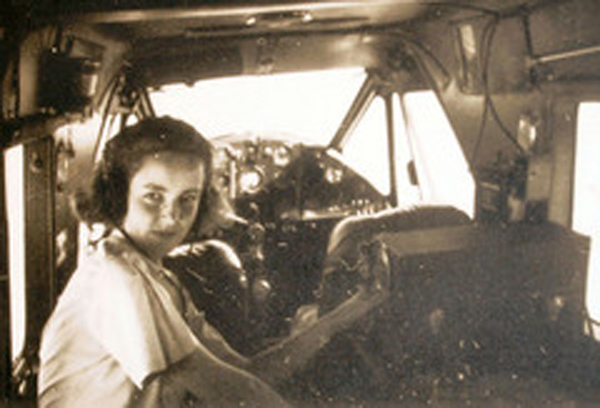
The Lights kept to a demanding schedule, flying all morning and visiting farms, mines, and local settlements in the afternoons as part of their project to record modern human activity in the African landscape. Although archaeology was not their primary interest on this trip, in Egypt they visited ancient sites including the temples at Luxor and the pyramids near Cairo.
The Fliers' and Explorers' Globe
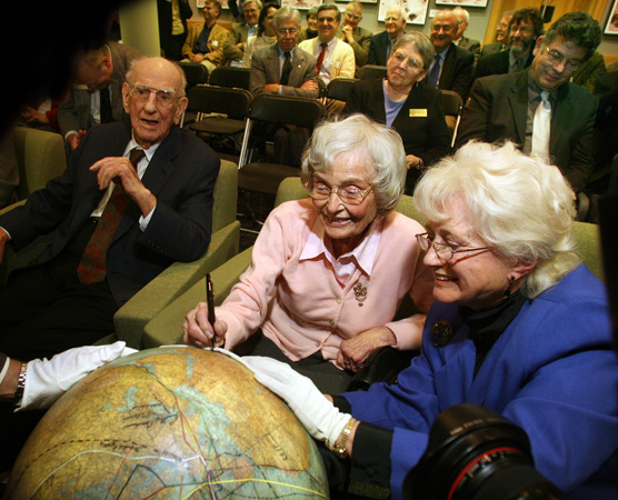
On November 21, 2006, Mary Meader became an honorary member of the American Geographical Society and was invited to sign her name on the famous globe that celebrates the pioneering spirit.
Measuring only 20 inches in diameter, “The Fliers’ and Explorers’ Globe” is one of the world’s most famous globes. Scribbled across its surface are the signatures of intrepid pioneers who defined the history of 20th-century flying and exploration: Charles Lindbergh, Amelia Earhart, the astronauts of Apollo 8, Robert Peary, Richard Byrd, and Sir Edmund Hillary. If you look closely, you can also see the signature of Mary Upjohn Meader, entered twice, once in Africa and once in South America.